Basically the canyon that forms drains Bagley Lake is a fault. On the west side of the lake is the Chilliwack River Terrane an accreted island arc, and on the east side are Mt. Baker Andesites. The Bagley Lakes trail parallels this drainage and crosses over a small dam, where you can see the difference in rocks from one side to the other.
 |
| Sam Looking at Mt. Baker Andesites |
 |
| Sam Looking at Chilliwack Terrrane |
 |
| From: Terranes of the North Cascades: Chilliwack River Terrane |
We saw a couple of nice metamorphic rocks on our hike. Admittedly the weather wasn't conducive to finding the best examples (and I am not great at identifying metamorphic rocks), but there were three areas that had distinctly different outcrops
 |
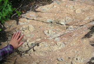
| Not sure with this one, originally thought it was a different metaconglomerate, but then thought about a fault Breccia, didn't know if that made sense. Help? |
Though I certainly saw the difference between the rocks, I was in "Look at the Mountain and Glacial Features mode" so I'm not sure if I would have put together the drainage was a contact between terranes. So thank you to the unnamed HS teacher I met. It certainly made more sense to look at rocks than mountains on that foggy day.


No comments:
Post a Comment