Monday, November 21, 2011

Just Refreshing All Y'all

I've been busy lately school, swimming, and all sorts of extra stuff. Now my dad has been keeping you guys caught up on all our trips but I was going through some of my pictures and thought to myself, hey why don't I do a post on some of our trips. That way you guys can here his geological side to our trips and my fun creative side. :-) Also I will tell you some more fresh stuff.


Now one of our trips he might have only briefly mentioned was in August after summer swimming was done we went to Newport, Oregon. On our way there we stopped at Bonneville Lock and Dam. I have already been there but since we brought along our cousins it was a unique experience for them and I had a good time.


We also stopped at Silver Falls. Which is close to Albany. We went on a hike called 11 waterfall hike. Both my mom and I enjoyed it, mostly for the nature scenes. I do think my dad enjoyed it but he was looking at more geological structures.


On the left is a picture of my favorite waterfall. On the right is a picture of me in a cave with a "well" on the ceiling.

When we got to Newport everyone was anxious to go to the beach. We had rented a little two housed building right across the street from the beach so during our down time it was fun to go play in the sand. Not everyone went swimming since we were in the upper part of Oregon we got ocean currents from the Artic Sea so the water was very chilly.
Well we were in Newport we saw a light house that had 107 steps all the way up. At the top you could get a little button that said "I survived the climb!" my dad got both my brother and I a button.


After we stayed in Newport for awhile we went to Crater Lake. We didn't do much at Crater Lake because it had been a long week and everybody wanted to get home but we did get to see these cool geologic structures. I don't remember the exact name. I do remember however that inside these is just air they are hollow.


All together it was a great trip and I'm looking forward to going back to Crater Lake (like my dad "promised") and hiking up Wizard Island. In tell next time.... peace out! :-)

Friday, October 14, 2011

Mt Baker cont

In previous posts, I wrote about our Rodeo Holliday trip that ended with a day at Heather Meadows on the side of Mt. Baker. The last notable thing about the trip was we had a great conversation about how science is supposed to work. At an earlier stop, I had pointed out the sun cups on top of the snow field, and mentioned that the how and why suncups form is a question that hasn't been completely answered. While exploring a snowbank Sam noted that there were suncup like features under the snowbank as well.


As we walked down the trail we made theories about how the suncup features would form on the bottom of a snowbank, and if the theories were testable. My theory was that it was based on the crystal structure of ice, but when pressed by Sam how I would test it, I did not have much of an answer. Her theory was the rocks under the snowbank (in the streams) initially forced the meltwater up over the rock creating the curved shape. Her test was to se if there was a correlation between cup location and size and an underlying rock.

At the next snowbank she ducked under to test her hypothesis

and sure enough there was a rough correlation between boulder location/size and suncup size. She repeated her observations at the next (last) snowfield we encountered and her subjective test held true. In the end she felt pretty proud she had come up with a theory that made more sense (to her) than her dad's and she was able to prove to him that she was right!

Wednesday, October 12, 2011

Mt Baker

In my previous post, I mentioned that on a Rodeo Holiday we went up to Heather Meadows on the Mt. Baker Highway. While we were there, we ran into a High School Geology class and the instructor pointed out to me that even though we couldn't see any mountains, there was some notable geology under foot.

Basically the canyon that forms drains Bagley Lake is a fault. On the west side of the lake is the Chilliwack River Terrane an accreted island arc, and on the east side are Mt. Baker Andesites. The Bagley Lakes trail parallels this drainage and crosses over a small dam, where you can see the difference in rocks from one side to the other.

Sam Looking at Mt. Baker Andesites

Sam Looking at Chilliwack Terrrane
  According to the USGS website on the Chilliwack Terrain, it is mostly phyllites and Greenstones that are thrust over the younger Nooksack Terrane.

Before the Chilliwack River terrane was thrust over the Nooksack terrane, its beds were folded upside down.
From: Terranes of the North Cascades: Chilliwack River Terrane
We saw a couple of nice metamorphic rocks on our hike. Admittedly the weather wasn't conducive to finding the best examples (and I am not great at identifying metamorphic rocks), but there were three areas that had distinctly different outcrops

Greenstone with quarts veins
 
Metaconglomerate
 
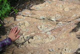
Not sure with this one, originally thought it was a different metaconglomerate, but then thought about a fault Breccia, didn't know if that made sense. Help?
Though I certainly saw the difference between the rocks, I was in "Look at the Mountain and Glacial Features mode" so I'm not sure if I would have put together the drainage was a contact between terranes. So thank you to the unnamed HS teacher I met. It certainly made more sense to look at rocks than mountains on that foggy day.

Tuesday, October 11, 2011

Return of Fall

I am taking my Physical Geology students on a field trip today so I turned on the weather channel to see what the weather was going to be like. A screenshot from their website shows the weather forecast for our area.


A bit of good news for me! As we are headed for that little gap in the rain shown by the arrow!

 But another section of the map caught my eye, that light blue swatch of snow along the Washington/Canada border. This is the area around Mt. Baker Ski area, and when Sam, Stanton, and I took a trip up there during our Rodeo Holiday in mid-September spring had just arrived.

It had been a gorgeous warm fall, and on the beginning of the Rodeo Holiday trip we had taken advantage of weather and went to the San Juan Islands.

 Because the weather was nice, and we were about as close as we would ever be, I thought we'd extend our trip a day and go up the Mt. Baker Highway. Mt. Shuksan is one of those oft photographed Mountains, and I wanted to see it for myself. However, by the time we got to Heather Meadows Visitor Center, this was the view that greeted us.

We had actually intended to go all the way to Artist point, but the road to Artist Point did not open this year because the snow never melted. There were record snowfalls (over 900 inches) and when they went to plow the road in July there was still over 50 feet of snow over portions of the road. With all that snow, summer never really arrived. We saw one willow bush that was still in bud.

Because of the snow we went on two short hikes near the visitor center. One, The Fire and Ice trail, which has placards which presumably highlight geologic features of glaciers and volcanoes, only the placards had not been put in yet for the season. We did see lots of neat basalt columns.

  
The columns were tilted in many places 
  
so you could see the tops too. 


and a nice cirque/tarn at the end far of the trail.


Despite the lack of view and winter like weather, I had a good time looking at the rocks. In fact a HS geology class was up there at the same time we were, and the instructor told me about some geology to look for which I'll summarize in a future post. 


Thursday, September 29, 2011

Summer Trips

I know it seems a little backwards, but now that classes are back in session, I have some time to catch up and blog about some of Sam and my summer trips.

Toward the end of July, Sam had a swimming competition in John Day. So we left a day early to go hike and to try and see some new stuff. First we tried to get up to the Elkhorn Ridge, but the 4WD approach road was more 4WD than my pseudo SUV could handle.

Next, we tried going hiking at Anthony Lakes, but there was too much snow on the trail, and we weren't prepared for that. So we headed down to lower elevations and visited the Sumpter Dredge Site.

The Dredge on display is the last of three dredges built between 1912 and 1934. It was operated until 1954 and dug up more than $4 million in gold (at about $34 per ounce). The three dredges together worked over 8 miles of river and created 1600 acres of tailings along the river bank.


 Sam is not all that interested in History so she wasn't that into the Dredge itself  (though we did have a good discussion hypothesizing what the white door that opened from the second deck out into empty space was for.) Sam was interested in paying for her college education, and she noticed gold glinting in the river, so we got a gold pan and a permit and she panned for a little while


Turns out fools gold is aptly named as that was the only color we had in our pan.

We still had time so we went down to the John Day Fossil beds. We had been here before, and I take a field trip every spring. But she got the obligatory picture in front of the Sheep Rock Fault, and I got to do some reconnaissance for future field trip stops.

It was a good trip, and as a final note, she won all her races at the meet the next day.

Thursday, July 7, 2011

Wallowa Lake

For the 4th of  July weekend, we decided to get out and see another of Oregon's geologic gems, Wallowa Lake.


Aside from being a rare large lake in eastern Oregon, Wallowa Lake is one of the best examples of a glacial morain damming a valley to form a lake. From a view point off the Mt. Howard Tram, the moraines forming the boundary of the lake are easily visible.

While the moraines are easily visible, it is hard to convey a sense of disproportionate scale. The moraines rise over 200 meters from the lake surface and almost 300m from the surrounding area. A road cut through the moraine along the edge of the lake reveals a poorly sorted mix of granitic and basaltic rocks, cobbles and smaller sediments.


Tuesday, July 5, 2011

Pacific Northwest NAGT #3 Diamond Craters

The Pacific Northwest NAGT meeting was supposed to have 4 days of field trips, and one day (Saturday) of meetings. This years meeting only had about a 1/2 day of meetings so Saturday afternoon we headed out to Diamond Craters,, BLM designated "Outstanding Natural Area". Diamond craters began erupting about 20 ka and according to the the Global Volcanism Program website was last active about 7 ka. But according to our guide, there may be indications of eruptive activity in archeological sites that are less than 500 years old. 
  
From the ORE BIN vol 26 No 2, Feb 1964 
Unfortunately time was limited so we were only able to make three stops in the area, but each stop represented a different kind of volcanism so it was a great overview of the eruptive history: The first stop was a pair of Maars at the western end of the road. The first was smaller and dry, but the second (Malheur Maar) was deep with an active mosquito breeding farm at the bottom.
Maars/craters are generally caused by the ejection of hot steam and other volcanic gasses. The pressure of these gasses blow a hole in the surface that becomes the crater, but the eruption containes little to know magmatic material. So at our second stop we saw an eruptive area that showed indications of fountaines of eruptive matieral. Red Crater was a lapilli crater built up to about a hundred feet on the eastern side. The rim was comprised of lapilli sized tephra that had fused while still molten. Scattered around the site were a number of "Breadcrust Bombs". Volcanic Bombs that were beginning to cool and harden on the outside while still molten and outgassing on the inside. The release of the internal gasses cause the bombs to continue to expand, stretching the outercrust creating cracks like a crust of baked bread. This bomb was found about 50 feet from the crater rim.

Our last stop was Lava Pit Craters. Actually three craters formed by drained Lava lakes. Eminating from each lake are a sereies of tubes and caves of highly basaltic lava. 


One of the pits has a large cave/tube with lavacicles hanging down and a hornito on top.
 
 
Unfortunately because our time was limited, we did not make the hike into the central vent area with more than 30 vents and some "dribblet spires" where smalll amounts of molten lava is forced to the surface with just enough energy to run down the sides as it cools. Sort of like the magma version of a drip sand castle.  Oh well, it gives me a reason to make the drive back. 

Friday, July 1, 2011

Pacific Northwest NAGT Field Trip #2

I began writing about the 2011 Pacific Northwest NAGT field meeting here. On Friday we circumnavigated Steens Mountain. The final stop was in Colony Canyon south of Fields, Oregon near the Oregon Nevada Boarder. The area was postulated to be accreted terrain that was originally near the continental craton, but has been moved hundereds of kilometers east by the extension of the Basin and Range Province. There were numerous outcrops of highly metamorphic rock, and not enough time to thoroughly explore.
Andy and Turk debate the Metamorphic grade of the outcrop
I am not strong on metamorphic rocks, but I know a nicely folded schist when I see one, and it makes a nice folded structure for a Friday.
The schist was actually folded by three separate events, the first forming the shist planes, the second altering the foliated planes into wavey folds, and finally a large tilting of the whole block to dip towards the north east. The layer on the right that appears to be intruding into the schist was interpreted by Turk and Andy to be Ultra-mylonite. The area was also full of granitic intrusions with lots of trace minerals, many of which I could not identify.

A great stop, but it would take a field season to really get a feel for all of the geology.

Thursday, June 30, 2011

Pacific Northwest NAGT

So last weekend I went to my first Pacific Northwest NAGT meeting. The meeting is a collection of mostly 2-year geology teachers who spend 4 days travelling around the area and one day of actual meetings.  Because this years meeting was located at Malheur Field Station in Southeastern Oregon, the first day of the meeting was spent getting there. As many of the participants (and the meeting host) were from the coast area they started near Salem and had a field trip driving to MF, while I took the more direct routes south on 395.

MFS is located northwest of the Steens Mountains on the border between the Basin and Range and the high volcanic plateau of Central Oregon. Although the Steens are an archtypical fault block mountain range, most of the features of the trip focused on Volcanic and Thermal features of the area. The Google map screen shot below shows some of the features we stopped to look at, with red balloons the stops that I will post about in this and the next couple of posts.


One of the first stops on Thursday served a dual purpose. The cap rocks shown below are Devine Canyon Tuff, and there is normal faulting down slope (north) that identifies the Brothers Fault. The Brothers fault at the surface is normal faults, but in general it is a strike slip fault that is the boundary between the relatively stationary Lava High Plains, and the (westward) extension of the Basin and Range to the south.

At this stop there was also a road cut through the tuff which afforded an up close look of the Devine Canyon Tuff. The Devine Canyon Tuff is one of four large welded tuffs in the area: The Rattlesnake (~7.02 Ma), Prater Creek (8.5 Ma), Devine Canyon Tuff (~9.7 Ma), and Dinner Creek (~15.5 Ma). The Devine Canyon Tuff eruptive center was ~20 miles northeast of MFS (~15 miles SE of Burns, OR) covered an area of 18,600 km2 (195,000 k3)to a fairly uniform thickness of about 30m. Because of its size, the Devine Canyon Tuff (and the Rattlesnake Tuff) is a good geologic markers throughout SE Oregon.

On Thursday we also drove north of Burns to look at the Rattlesnake welded Tuff (235,000 km3 with an eruptive center (~50 miles NW of MFS), and where the Dinner Creek Welded Tuff contacted the Mesozoic aged accreted terrain that makes up of much of Oregon (but is mostly covered by Tertiary Volcanics) 

On Friday we set out for a ~250 mile circumnavigation of the Steens Mountains. The east face of the Steens is steep exposures of Steens Basalt, and older layers. This vantage point is from the NE looking down Pleistocene Lake Bed at the base of the Range

Further along, we stopped at Mickey Hot Springs, a series of thermal pools that are being investigated for their potential to produce commerciall scaled geothermal energy. There were a series of hotsprings and abandoned vents in the area. The stricking thing to me though was the overall lack of thermal deposition. There was some sinter, and some algal mats that had lithified, but the area was very low in carbonate deposites that are often associated with thermal areas; in fact the water at the hot springs is fairly low in any dissolved ion content, which is part of what makes it attractive as a geothermal resource. Lastly, because the source of the hot water is not magma (it is hypothesized to be fault driven) so the thermal area had almost no SO2 and the associated sulfur smell. All in all it was a pleasant place to lunch. 

Friday, May 27, 2011

Goblin Valley is Weird

When I lived in Utah, my sister would often come and visit. We would make excursions to Southern or Eastern Utah, and she would always remark how weird some of the landscapes are. To me the epitome of weird Utah landscapes is Goblin Valley State Park, just North of Hanksville. My first trip to Goblin Valley was on Halloween, where a number of friends gathered to play hide and seek amongst the "goblins" that evening.

Goblin Valley was also my first introduction to the term "hoodoo" which remains one of my favorite geologic terms. To me, the sound of the word "hoodoo" perfectly describes the eerie shapes of Goblin Valley


Goblin Valley Panoramic Collage

This past spring break I came back to the hoodoos of Goblin Valley and got some pictures of Sam as she explored them.

Sam and Goblins

Wednesday, May 25, 2011

Spring Field Trip

This past week I took my Introduction to (Historical) Geology class on its annual field trip to the John Day Fossil Beds. We had a gorgeous day (in betwen days of heavy rain), plus his year I identified a couple of new stops that the students really liked, and I think added a lot to the trip.

The first new stop (for me) was a stop identified in the USGS field trip guide to the Geologic Setting of the John Day Country. Less than 1/2 mile down Fields Creek Road is a geologic marker and a road cut through some volcanic ash beds of the Mascall Formation. Students spent a good 45 minutes going through the ash beds looking for leaf fossils and nut impressions.


The other new stop was an outcropping just north of the Condon Visitors center on Highway 19. The Road and River cut through a large outcropping of Goose Rock Conglomerate. I often have a hard time getting students to recognize conglomerate because many of the hand samples I have in lab the clasts are gravel sized. But the Goose Rock conglomerate has cobble sized clasts that are nicely rounded (pencil for scale).


Not only is it an excellent example of conglomerate but it is a great rock to help tell the history of Oregon. The conglomerate itself is mid Cretaceous which makes it among the older rocks in Oregon. The clasts are largely comprised of greenstones, cherts, gabbros, and granite that are early Cretaceous age. The greenstone and granite really help because they represent the oceanic and terrestrial components of a volcanic island arc that accreted onto the margin of the continent and then weathered and deposited in the floodplains of a Mesozoic river.


Friday, April 22, 2011

Earth Day

Happy Earth Day
Devils Garden Campground and Skyline Arch, Arches National Park
Been a busy week, but I wanted to celebrate Earthday witih a picture from our Spring Break trip to Arches

Thursday, April 21, 2011

Biology

In Science Class we are studying Biology and today we had a live lamb and a dead lamb brought in. We have a few class clowns and they wanted to name the live lamb Lamb Chops.


Oh and a fare warning if you do not like to see blood please do not look at the pictures. So as I said we brought in a live lamb and a dead one [Philip says - the science teacher's friend raises sheep, so the lamb brought in for dissection was one which did not survive the spring weather]. We also got to dissect the dead one. As we were dissecting the dead one we let the live lamb roam around the class room. But before we started dissecting we got to feed the live lamb.

Feeding the lamb

When we were done feeding we finally got to open up the dead lamb. After we opened it up we took out the heart then we took out the liver and gallbladder after that we got to feel around inside of it and I think some of my classmates went to extremes on that.


Lamb insides


Lamb Heart


After a while of letting people feel the lambs inside we cut open skull to see the brain. As we were cutting open the skull you could hear it crack every time we moved the knife. Then we let people feel the brain and after (almost) everyone felt it Mr. S asked what it felt like and if we could describe the difference between the brain and the intestines. They all answered that the brain was hard and not as "squishy."
Lamb's Brain
After people got to feel that we took out an eyeball. When I got to hold the eye I observed that it was hard and not as soft as the intestines or stomach. Which surprised me because I always thought an eye ball was softer than that.
Lamb's Eye


When we had to go clean up I decided to get a pic of my hands


My Bloody Hands


Science today was really fun and I hope that the sixth grades next year enjoy it to.
Sam