Showing posts with label Accretionary Wedge. Show all posts

Friday, May 27, 2011

Goblin Valley is Weird

When I lived in Utah, my sister would often come and visit. We would make excursions to Southern or Eastern Utah, and she would always remark how weird some of the landscapes are. To me the epitome of weird Utah landscapes is Goblin Valley State Park, just North of Hanksville. My first trip to Goblin Valley was on Halloween, where a number of friends gathered to play hide and seek amongst the "goblins" that evening.

Goblin Valley was also my first introduction to the term "hoodoo" which remains one of my favorite geologic terms. To me, the sound of the word "hoodoo" perfectly describes the eerie shapes of Goblin Valley


Goblin Valley Panoramic Collage

This past spring break I came back to the hoodoos of Goblin Valley and got some pictures of Sam as she explored them.

Sam and Goblins

Monday, March 7, 2011

Favorite Geology Picture -AW#32

In a post about Multnomah Falls and Columnar Jointing, I posted this picture taken of Sam at Devil's Tower a few years ago. It remains one of my favorite pictures of geology (and Sam) as it provides such a great image to show several geologic principles at ones. Aside from the geologic signficance of the tower itself, the promionant geologic feature is the massive hexagonal piece that 7-year old Sam (for scale) is leaning against. Behind it, you can see the joints extending up the tower with clear hexagonal blocking roofs, allowing one to recognize the block as having weathered and fallen off the tower.

The picture also has trees and shrubs growing in the fractures below the main part of the tower. These fractures are not the columnar jointing of above, and so demonstrate a different condition of cooling for the base of the tower. The fractures below also have trees and shrubs growing amids the fractures illustrating yet another form of mechanical weathering.

Monday, October 25, 2010

Lavacicles

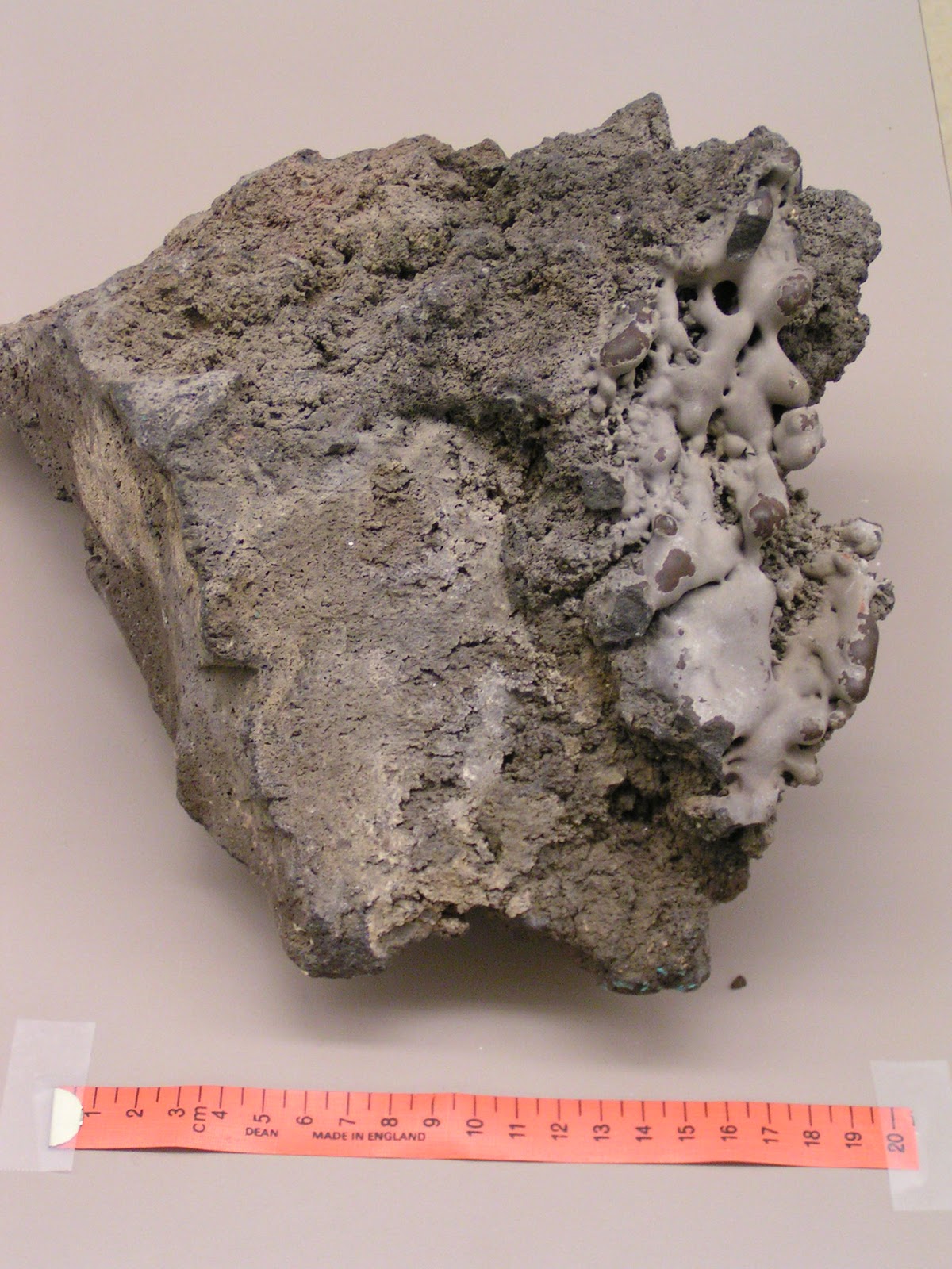
The theme fo this month's accretionary wedge is Desk-crops. My favorite deskcrop is one I inherited when I took over my current classroom lab. Because I inherited it, I don't know much of its history although I will assume it was collected somewhat locally. Although it is one of my favorites now, I'll admit that for the first couple of months, I didn't really look at it;  I thought it was another piece of basalt. Sure it had a nice blocky texture and vesicles, but in all, I just considered it another piece of basalt, like the kind we find all over around here.

But then, the former lab instructor started telling me about some of her favorite rock samples in the lab. She mentioned one with "lavacicles," so I got to looking for it, turned over this sample and there they were.

If you look at the right side of the block you can see the texture is much smoother, and the rock forms nice rounded surfaces, like drips frozen in time. I interpret this as once having been at or near the top of an old lava tube, the heat from a subsequent flow was sufficient to remelt a portion of the surface forming the lavacicles.

Sunday, September 26, 2010

Devils Tower


My Dad asked me to write what my most interesting experience in geology was. It was when we stilled lived in Montana, we went to Devils Tower. I thought of it as a big rock that was not a mountain. I liked camping there and waking up to see the sunrise. We took a walk around the base and we saw a huge Pine Snake!
Sam


Friday, May 14, 2010

Accretionary Wedge


This month's Accretionary Wedge is being hosted by Highly Allochthonus. For my first ever submission to this Geo-blogging carnival I am adding an image I took in Makoshika State Park, Montana. I had the fortune to teach at a small community college near there for four years, and treasured the time that I got to spend exploring the park and prospecting for fossils. I use this image in class when I sedimentary rocks and stratigraphy, I also talk about the paleo-environment that would have resulted in the sandstone/claystone/coal beds seen in the picture, and because this image shows the K/T boundary between the Hell Creek Formation and the Fort Union Member of the Tullock Formation, I use it again when I talk about the K/T boundary.

An annotaded version is shown below


Although the iridium layer has been identified in the Hell Creek/Fort Union boundary, it has not yet been looked for at Maksoshika State Park. Also, the K/T boundary and the irridium layer have been identified as the lowest contiguous coal bed "Z-coal" the fossil record show the transition between Cretaceous and Tertiatry aged fossil to be a couple of meters below the boundary coal. Interestingly the distribution of Cretaceous fossils in this area was used by J.Keith Riby citation needed as evidenc of gradual extinction, while Sheehan et al. 2000 found evidence of abrupt extinction.

Philip