Showing posts with label Field Trips. Show all posts

Tuesday, July 5, 2011

Pacific Northwest NAGT #3 Diamond Craters

The Pacific Northwest NAGT meeting was supposed to have 4 days of field trips, and one day (Saturday) of meetings. This years meeting only had about a 1/2 day of meetings so Saturday afternoon we headed out to Diamond Craters,, BLM designated "Outstanding Natural Area". Diamond craters began erupting about 20 ka and according to the the Global Volcanism Program website was last active about 7 ka. But according to our guide, there may be indications of eruptive activity in archeological sites that are less than 500 years old. 
  
From the ORE BIN vol 26 No 2, Feb 1964 
Unfortunately time was limited so we were only able to make three stops in the area, but each stop represented a different kind of volcanism so it was a great overview of the eruptive history: The first stop was a pair of Maars at the western end of the road. The first was smaller and dry, but the second (Malheur Maar) was deep with an active mosquito breeding farm at the bottom.
Maars/craters are generally caused by the ejection of hot steam and other volcanic gasses. The pressure of these gasses blow a hole in the surface that becomes the crater, but the eruption containes little to know magmatic material. So at our second stop we saw an eruptive area that showed indications of fountaines of eruptive matieral. Red Crater was a lapilli crater built up to about a hundred feet on the eastern side. The rim was comprised of lapilli sized tephra that had fused while still molten. Scattered around the site were a number of "Breadcrust Bombs". Volcanic Bombs that were beginning to cool and harden on the outside while still molten and outgassing on the inside. The release of the internal gasses cause the bombs to continue to expand, stretching the outercrust creating cracks like a crust of baked bread. This bomb was found about 50 feet from the crater rim.

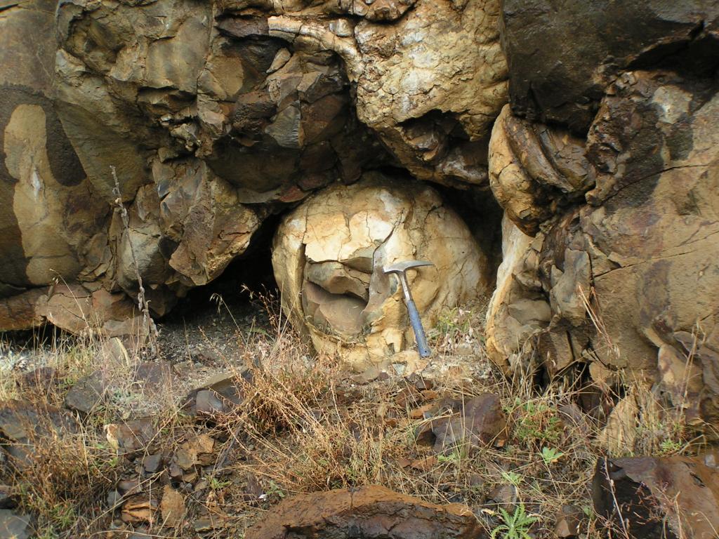
Our last stop was Lava Pit Craters. Actually three craters formed by drained Lava lakes. Eminating from each lake are a sereies of tubes and caves of highly basaltic lava. 


One of the pits has a large cave/tube with lavacicles hanging down and a hornito on top.
 
 
Unfortunately because our time was limited, we did not make the hike into the central vent area with more than 30 vents and some "dribblet spires" where smalll amounts of molten lava is forced to the surface with just enough energy to run down the sides as it cools. Sort of like the magma version of a drip sand castle.  Oh well, it gives me a reason to make the drive back. 

Friday, July 1, 2011

Pacific Northwest NAGT Field Trip #2

I began writing about the 2011 Pacific Northwest NAGT field meeting here. On Friday we circumnavigated Steens Mountain. The final stop was in Colony Canyon south of Fields, Oregon near the Oregon Nevada Boarder. The area was postulated to be accreted terrain that was originally near the continental craton, but has been moved hundereds of kilometers east by the extension of the Basin and Range Province. There were numerous outcrops of highly metamorphic rock, and not enough time to thoroughly explore.
Andy and Turk debate the Metamorphic grade of the outcrop
I am not strong on metamorphic rocks, but I know a nicely folded schist when I see one, and it makes a nice folded structure for a Friday.
The schist was actually folded by three separate events, the first forming the shist planes, the second altering the foliated planes into wavey folds, and finally a large tilting of the whole block to dip towards the north east. The layer on the right that appears to be intruding into the schist was interpreted by Turk and Andy to be Ultra-mylonite. The area was also full of granitic intrusions with lots of trace minerals, many of which I could not identify.

A great stop, but it would take a field season to really get a feel for all of the geology.

Thursday, June 30, 2011

Pacific Northwest NAGT

So last weekend I went to my first Pacific Northwest NAGT meeting. The meeting is a collection of mostly 2-year geology teachers who spend 4 days travelling around the area and one day of actual meetings.  Because this years meeting was located at Malheur Field Station in Southeastern Oregon, the first day of the meeting was spent getting there. As many of the participants (and the meeting host) were from the coast area they started near Salem and had a field trip driving to MF, while I took the more direct routes south on 395.

MFS is located northwest of the Steens Mountains on the border between the Basin and Range and the high volcanic plateau of Central Oregon. Although the Steens are an archtypical fault block mountain range, most of the features of the trip focused on Volcanic and Thermal features of the area. The Google map screen shot below shows some of the features we stopped to look at, with red balloons the stops that I will post about in this and the next couple of posts.


One of the first stops on Thursday served a dual purpose. The cap rocks shown below are Devine Canyon Tuff, and there is normal faulting down slope (north) that identifies the Brothers Fault. The Brothers fault at the surface is normal faults, but in general it is a strike slip fault that is the boundary between the relatively stationary Lava High Plains, and the (westward) extension of the Basin and Range to the south.

At this stop there was also a road cut through the tuff which afforded an up close look of the Devine Canyon Tuff. The Devine Canyon Tuff is one of four large welded tuffs in the area: The Rattlesnake (~7.02 Ma), Prater Creek (8.5 Ma), Devine Canyon Tuff (~9.7 Ma), and Dinner Creek (~15.5 Ma). The Devine Canyon Tuff eruptive center was ~20 miles northeast of MFS (~15 miles SE of Burns, OR) covered an area of 18,600 km2 (195,000 k3)to a fairly uniform thickness of about 30m. Because of its size, the Devine Canyon Tuff (and the Rattlesnake Tuff) is a good geologic markers throughout SE Oregon.

On Thursday we also drove north of Burns to look at the Rattlesnake welded Tuff (235,000 km3 with an eruptive center (~50 miles NW of MFS), and where the Dinner Creek Welded Tuff contacted the Mesozoic aged accreted terrain that makes up of much of Oregon (but is mostly covered by Tertiary Volcanics) 

On Friday we set out for a ~250 mile circumnavigation of the Steens Mountains. The east face of the Steens is steep exposures of Steens Basalt, and older layers. This vantage point is from the NE looking down Pleistocene Lake Bed at the base of the Range

Further along, we stopped at Mickey Hot Springs, a series of thermal pools that are being investigated for their potential to produce commerciall scaled geothermal energy. There were a series of hotsprings and abandoned vents in the area. The stricking thing to me though was the overall lack of thermal deposition. There was some sinter, and some algal mats that had lithified, but the area was very low in carbonate deposites that are often associated with thermal areas; in fact the water at the hot springs is fairly low in any dissolved ion content, which is part of what makes it attractive as a geothermal resource. Lastly, because the source of the hot water is not magma (it is hypothesized to be fault driven) so the thermal area had almost no SO2 and the associated sulfur smell. All in all it was a pleasant place to lunch. 

Wednesday, May 25, 2011

Spring Field Trip

This past week I took my Introduction to (Historical) Geology class on its annual field trip to the John Day Fossil Beds. We had a gorgeous day (in betwen days of heavy rain), plus his year I identified a couple of new stops that the students really liked, and I think added a lot to the trip.

The first new stop (for me) was a stop identified in the USGS field trip guide to the Geologic Setting of the John Day Country. Less than 1/2 mile down Fields Creek Road is a geologic marker and a road cut through some volcanic ash beds of the Mascall Formation. Students spent a good 45 minutes going through the ash beds looking for leaf fossils and nut impressions.


The other new stop was an outcropping just north of the Condon Visitors center on Highway 19. The Road and River cut through a large outcropping of Goose Rock Conglomerate. I often have a hard time getting students to recognize conglomerate because many of the hand samples I have in lab the clasts are gravel sized. But the Goose Rock conglomerate has cobble sized clasts that are nicely rounded (pencil for scale).


Not only is it an excellent example of conglomerate but it is a great rock to help tell the history of Oregon. The conglomerate itself is mid Cretaceous which makes it among the older rocks in Oregon. The clasts are largely comprised of greenstones, cherts, gabbros, and granite that are early Cretaceous age. The greenstone and granite really help because they represent the oceanic and terrestrial components of a volcanic island arc that accreted onto the margin of the continent and then weathered and deposited in the floodplains of a Mesozoic river.


Friday, November 12, 2010

Fall Field Trip II - Ukiah to Heppner

Once we reached the Ukiah turn-off, we headed west towards Heppner on US Forest Road 53 on the Blue Mt. Scenic Highway. This stretch of road goes over the Blue Mt. Anticline, and a paper by Edwin Shorey  (1976, Geology of Part of Morrow County, Northeast Oregon, Masters Degree Thesis, Oregon State University) suggested that you could map the outcrops over the anticline showing the progression to older units and then back again.

I had been a little worried about this stretch because it is unmaintained in the winter, and it had been drizzling/raining lower down, but the sun came out and it was mostly a nice drive with just a little snow on the road at the summit.

Our first stop was a Pillow Basalt oucropping that Stan had told me about. When I had driven the road before, I went right past it, but this time (knowing it was about 3 miles up the road) we saw it. Nicely formed pillows beneath a more typical CRB columnar basalt
 

Most of the pillows were about 50cm in diameter and well formed, with 2-3 pillow layers reaching a total height of about 2meter. The whole exposure was only about 100m long, with the good pillows being confined to about 20m.  

 After the pillow basalts, we continued up over the road for about 8 miles. By and large, there were no rock outcrops or road cuts through this area, and what there was consisted of broken basalts. We stoped at a gravel pit hoping for a nice compotent outcrop but while there were no faces in the gravel pit, the road cut on the other side had some intact basalt columns. 

 Mike cleaned the debris off the top of one of the column so that we could see the hexagonal shape going back into the outcrop.


As we proceded on towards the axis of the anticline we came into the Herren Formation. The Herren Formation is interpreted on Birch Creek as being Fluvial sequences of arkose, mudstone, and shale with Leaf Fossils that indicate an early Eocene age. The Herren Formation also has localized coal seams that give the area its name "Coalmine Hill". We spent some time looking for leaf fossils but did not find any.

At the bottom of Coalmine hill, there is an outcropping of late Jurassic aged tonalite that is similar in age to the granite we saw on Battle Mountain. Although outcrops looked similar, the tonalite outcropping was more competent than the granite, and there were large (5mm) biotite crystals in the tonalite.

 Also intruded into the tonalite were veins of a powdery fine grained mafic material. There was evidence of contact metamorphism along the edges of these veins, but what was interesting to me was that the core of the vein had a powdery texture. I think what we were seeing is evidence of Tertiary intrusions, but why they are no competent veins I guess I do not know.
On our down Willow Creek, we ran back into the Herron Formation on the other side of the anticline axis. Here, different beds of sand could be visibly seen and were dipping strongly back towards the axis of the anticline. Overlying the Herron Formatio was a nonconforming contact of river cobbles and gravels. We spent some time practicing with our Bruntons and then moved on, but this was an outcrop I'd like to spend more time looking at.

Our last stop was back in the CRB's looking at columns again. These colums were smaller, but not vertical. At this location we saw columns oriented in all directions with some dipping as much as 50 degrees.
 Also at out last stop we noticed this little guy.I was pretty surprised to see him out on such a cool day in Late October, but there was a little sun that he was enjoying.


Thursday, November 11, 2010

Fall Field Trip Part I - Pendleton to Ukiah

Last week I took two students on a drive to look at some of the rock outcrops in the area. I often complain that all you ever see around the area are Columbia River Basalts, but we did find some other outcrops too. Our first stop was a whole 1/4 mile from the college parking lot, at the bottom of the hill. From there we got a close up look at the ubiquitous CRBs in the area. The three layers seen in this photo are accross the river valley from the same (but better) formation I posted about in September.


The top layer, characterized by the grayer more blocky rock is the Frenchman Springs member of the  Wanapum flow. The broad reddish band in the middle is the Vantage soil horizon, on the edges of the horizon there are some baked contacts where the clayey soils have been baked into a marble. At the bottom, looking more like a talus field in this image is the Sentinel Bluffs Member of the Grande Ronde Flow.

In class we have been talking about weathering and sediment transport in class so our next stop was at some Late Miocene deposits in the McKay formation. The alluvial beds are mostly sand, gravel, and cobble, but on some of the north facing slopes there is also Pleistocene Loess.


While poking around, one of the students noticed some mechanical weathering on one of the cobbles, so we could nicely compare the differences between material that had freshly weathered and materiails that had been rounded through transportation. 


The next stop on our field trip was a road cut through Cretaceous aged intrusive outcrop of granodiorite just north of Battle Mt. State Park. The outcrop is heavily weathered with a 5m pile of scree at the bottom, and a nonconformity with the Miocene Grand Ronde Basalts above it.


From the road, the cliff looks real nice, but when you get up close to the rock you notice it is full of quartz veins and really crumbly. We investigated whether it was just excessive surface weathering by digging in 10-15cm with the rock hammer, but it still came out crumbling in our hands. Because the formation is near some thermal springs, we posited that much of the rotten nature of the rock was due to historical contact with some of these thermal features.
Eddie Looking at the quartz veins, note a small bird hole just above his hand
Most of the quartz veins were fairly competent, but there were some that had almost pure quartz powder. This vein was fillled with quartz grains that had the size and texture of white flour.


After Battle Mountain we continued on 395 to  Ukiah and the second part of the Field Trip was over the Blue Mountain Scenic Highway from Ukiah to Heppner.