Friday, January 28, 2011

Sam's Science Chat

In science we have a thing everyday called "interesting science fact of the day." this week all of them are based either on electricity or lightning which technically speaking are the same. Even tho lightning bolts have electricity the charge is brief so you couldn't use it to have a reading lamp on for thirty minutes. Lightning is an electric current ( electric current is the continuous flow of electrons within a conductor.) Within a thundercloud, many small bits of ice bump into each other as they swirl around in the air. All those collisions create an electrical charge. After a while, the whole cloud fills up with electrical charges (usually with a negative charge closest to the earth). Since opposites attract each other, that causes a positive charge to build up on the ground beneath the cloud. The ground's electrical charge concentrates around anything that sticks up, such as mountains, lone trees, people, or even blades of grass. The charge streaming up from these points eventually connects with a charge reaching down from the clouds, and--zap!--lightning strikes.

Have you guys heard of the Chaiten Volcano in southern Chile that erupted on Sep. 22, 2008 if not please click the date erupted and you will find a article. This volcano has lightning in its ash cloud.

I went on to google.com to see why there is lightning in a ash cloud and I found this on answers.yahoo.com they had what they called "the best answer" which is this...
The same process that goes on in any thunderstorm, rising turbulent warmer air causing static charges because of friction in the air, is being artificially created around the warm rising turbulent air from an eruption. Not only is ash rising, but huge amounts of hot water vapor is released as well. As the water vapor cools in the upper atmosphere, not only do you get lightning and thunder, but it also is likely to rain heavily which makes the ash fall even worse when it falls on top of buildings, by adding a lot of water weight to the ash. I saw a documentary on Mount Pinatubo in the Philippines recently on National Geographic and they showed the whole process. This only happens when there is a violent eruption. The low, slow flow like that in Hawaii does not cause any local weather effect as a violent explosive eruption does.
So that is a little bit about lighting and volcanoes.

Thursday, January 27, 2011

Inversion

So I had to take Sam over the hill today for an orthodontist appointment. As we left this morning, we both noted the morning fog was pretty dense, and as we climbed up on Cabbage Hill, Sam got out her phone to take pictures of the fog in the valley's, she said it was pretty. I was thinking "inversion."

So on the way home, we stopped I kept track of the temperatures as we came back down off the anticline. We stopped at an overlook just pass Dead Mans Pass an elevation of about 3600'. The temperature was 42F, it was mostly sunny and you barely could see Mt. Rainier 180 miles away.

As we drove the 5 miles or so down Cabbage Hill, I kept track of the temperature on my dashboard thermometer, not great but usually good to within about 2F. At the road cut into the Patawa Creek drainage at elevation about 2800 feet, the temperature was 46F, and as we reached the top layer of the clouds at an e elevation of about 1600 feet, the temperature was 48F. This fits a normal environmental lapse of about 3F per 1000 feet.


We entered the Fog bank appropriately to Pink Floyd's "Is there anybody out there" track off The Wall, and with in a mile, the visibility dropped to less than 1/4 mile, and the temp plummeted to 34F.

 The long and short of the science is over the past few days High Pressure has been building over the Columbia Plateau, generating stagnant air warnings in the Portland and the Columbia Basin. In the morning, the cold air gets trapped in the valley where it meets the warm moist air that comes up the Columbia River creating a fog. That fog prevents sunlight from warming the air keeping the cold air inverted under the warmer air above.
 
On a final note, when we got home, there was even drops of rain falling on the driveway. I pointed out to Sam that it was weird given how sunny it had just been on the hill. She looked at me and said "its not rain, its the water moisture that makes up clouds coming out [condensing] on the tree branches and then dropping." When I noted she was correct she added, "just thinkin' like a scientist!"

Thursday, January 20, 2011

Oregon Coast

After Stanton's concert on Saturday, we headed for the Oregon Coast and drove north from Florence to Lincoln City. It was warm, but very windy and raining hard so we did not make as many stops as I wanted, but I guess that gives us reason to go back.
Hecata Head Lighthouse

Our one long stop was at the Cape Perpetua area. Even though it was low tide, the wind was blowing the waves into the basalt nooks putting on a very good show of spouts and sprays. Sam went exploring tide pools while I tried to get pictures of sprays and rocks. It was interesting walking on the basalt because despite all of the rain and wind, the traction was very good. It was also interesting to see the basalt fracturing into fins that ran mostly perpendicular to the coast. Because of the rain I really didn't get any good pictures other than this one of Thor's Well

Thor's Well
We had a lot of fun, but it was wild weather. I haven't been in rain/wind like that since I was on othe Juneau Icefields in 1991. After about 20 minutes we were soaked to the bone, but we had fun!


Monday, January 17, 2011

U of O Natural History Museum

We were in Eugene on Friday because Stanton was singing in the State Honors Choir. While he was at rehearsal, we decided to check out the Museum of Natural and Cultural History on the University of Oregon campus. The museum is small with one large room dedicated to the cultural history of the four regions of Oregon. There is a smaller room with a permanent geology display. Placards outlined the geological differences between the Coast, the Cascades, the Columbia Plateau, and the Basin and Range parts of the state and beneath the placards were small geology displays. Beneath one of the placards was a display case that had the major rocks found in the different areas of the state.

And that was more or less the extent of the permanent geology display. I was kind of disappointed there wasn't more on gems and minerals, or at least sunstones (the state gem) or thundereggs (the state rock).

The discovery area was another small room where there were an assortment of hands on activities for kids and kids at heart. One was a simple cubbyhole cupboard with different rocks divided into igneous, metamorphic and sedimentary categories. To each rock was glued an identification card and some questions about the rock and there was a magnifying glass close at hand so you could look closely at them.


Next to the discovery area was a small Paleolab, where kids could "find" specimens, describe and investigate them, and finally classify and catalogue them. Sam had fun here, dressing up in the lab coat and playing with the caliper to measure a piece of petrified wood.

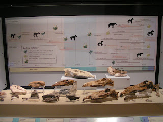
The best exhibit was a small temporary exhibit (through April 2011) on the fossil evolution of horses and the change in horse evolution as it relates to climate change, much of which comes from fossils found in the John Day Fossil Beds of Oregon.


In the discovery area, they had puppet horse feet that you could try on soft surfaces (forest) or hard grass lands. Sam like the last one because since a modern horse essentially runs on its middle finger, you essentially put your hand in the puppet with your middle finger out.